
On October 1, Russian troops attacked the South Bridge in Kyiv. According to the capital’s mayor, Vitali Klitschko, two drones struck near the bridge’s support structure. Following the attack, metro and surface public transit services across the bridge were temporarily suspended, and specialists from Kyivavtoshlyakhmost began inspecting the structures.
One of the strikes occurred just as a subway train was traveling along the open section of the Syretsko-Pecherska Line. Passengers reported an explosion, a flash of light, and smoke in the car. The train was able to continue on to “Vydubychi”; according to preliminary reports, there were no injuries among the passengers.
Today, the South Bridge is primarily regarded as one of the capital’s main transportation arteries. However, its history is much broader. It was one of the most complex engineering projects in late-Soviet Kyiv, the first cable-stayed bridge in the USSR to carry rail transit, and a structure intended to solve the city’s transportation problems for decades to come.
UA.News explains why Kyiv needed the South Bridge, how it was built, why a restaurant nearly opened inside one of its pylons, and just how serious the consequences could be if major bridges across the Dnipro were struck.
Kyiv was building new neighborhoods but had no way to connect them to the right bank
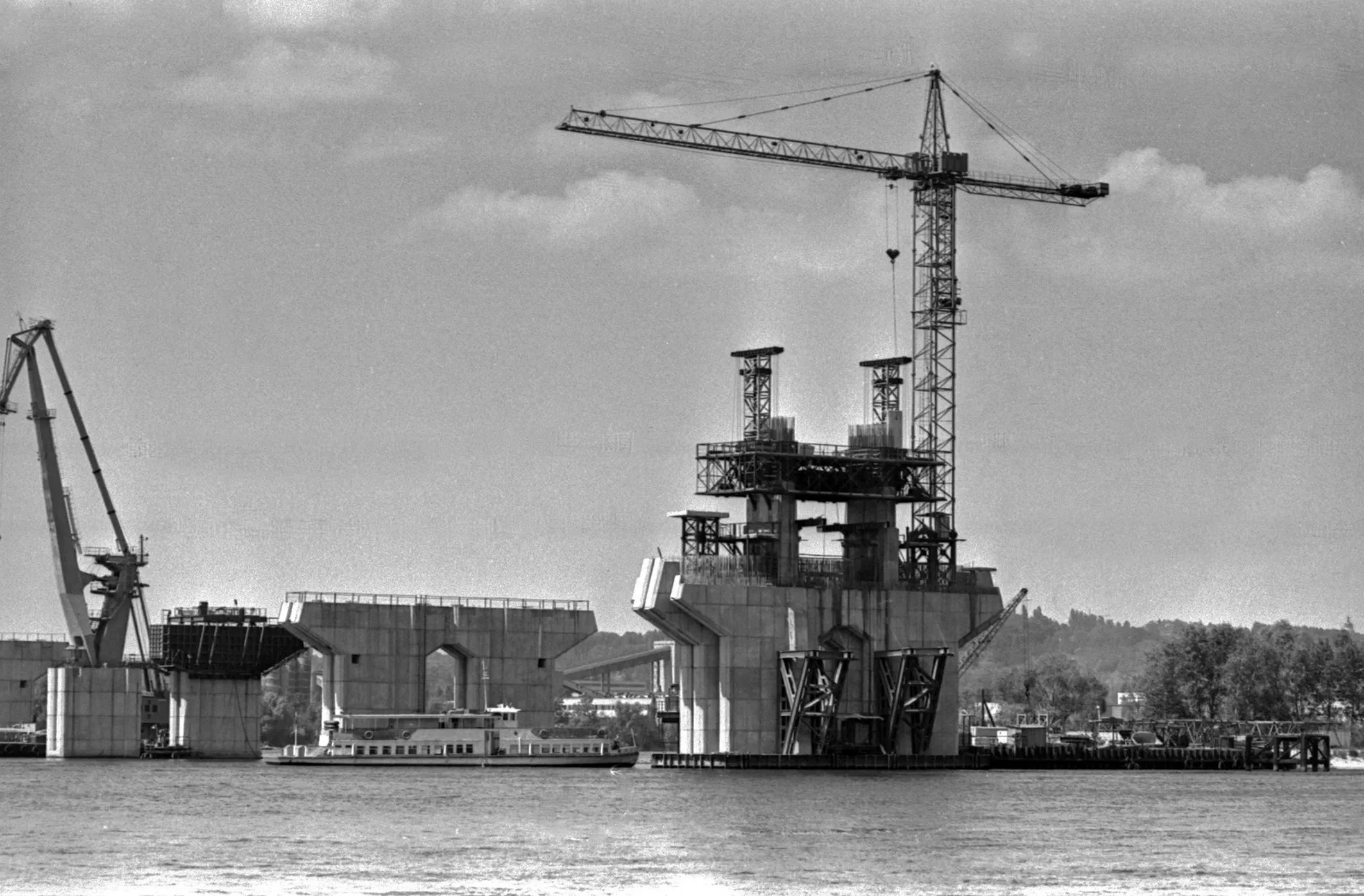
The history of the South Bridge actually began not with the bridge itself, but with the large-scale redevelopment of Kyiv in the late 1970s and early 1980s.
On the left bank, active development began in the Poznyaky and Osokorky areas. Large residential complexes were to be built there, bringing with them hundreds of thousands of new residents. At the same time, most of Kyiv’s jobs, administrative institutions, and central districts remained on the right bank.
The existing crossings over the Dnipro were no longer sufficient. At the same time, the city began construction of a third metro line—the Syrets-Pechersk Line. It was intended to run from central Kyiv to the left bank and serve as the main transportation link to the new districts.
This required a new bridge capable of handling both cars and subway trains simultaneously.
Georgy Fuks—one of Kyiv’s most renowned bridge builders—became the chief engineer of the future bridge. Prior to the Pivdennyi Bridge, he had already worked on the Metro Bridge and what was then known as the Moskovskyi Bridge (now the Pivnichnyi Bridge). Alexei Gavrilov became the chief architect, and Mikhail Korneev was one of the lead engineers.
Initially, several options for the new bridge’s location were considered. It could have been built much further south—as an extension of Nauky Avenue or Akademika Zabolotnogo Street. Ultimately, it was decided to route the bridge via Saperno-Slobidska Street toward Vydubychi.
It was this route that later transformed the South Bridge not only into a link between the two banks but also into one of the main routes from the center of Kyiv toward Boryspil.
The Southern Bridge took seven years to build
Construction of the bridge began in 1983. For Kyiv, this was an extremely complex project. It was decided to build a cable-stayed bridge—that is, part of the roadway was to be supported by a tall pylon and a system of steel cables.
At that time, experience with building large cable-stayed bridges in the USSR was relatively limited. Engineers performed a significant portion of the complex calculations by hand, while for the most challenging tasks, they relied on the electronic computers available at the time.
During construction, 14 new technical solutions were developed and implemented. Sections of the superstructure were manufactured as separate factory-made blocks—which the builders referred to as “little birds”—and then assembled directly over the Dnipro River.
The Southern Bridge Crossing is actually much larger than the structure that most Kyiv residents have come to refer to simply as “the bridge.” It includes traffic interchanges, the right-bank viaduct, the reinforced concrete section over the Dnipro, and the steel cable-stayed navigable section. The main navigable span allowed for a significant amount of space above the river without intermediate supports.
The bridge itself is over 40 meters wide. It features six lanes of traffic—three in each direction—two subway tracks, and pedestrian walkways. Utility lines have also been routed through the structure.
One of the most recognizable features is the pylon with its cable-stayed system. It is this pylon that defines the silhouette of the South Bridge, which today is easily recognizable from virtually any point in the southern part of Kyiv.
There were plans to open a restaurant on the pylon and enclose the subway with glass
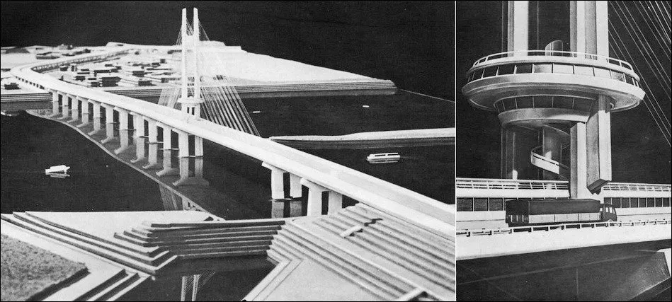
During the design phase, the South Bridge could have looked completely different. One of the most ambitious ideas was to build a restaurant directly on the pylon. A similar design already existed on the SNP Bridge in Bratislava, and Kyiv engineers wanted to create their own version of such a structure.
In early models, the restaurant resembled a large plate at the top of the pylon. But implementing the plan proved too difficult. The nearest shore was about half a kilometer away; there was no way to create adequate parking nearby, and there were issues with water supply, sewage, and other utilities. The restaurant idea was ultimately scrapped.
The metro section was supposed to be no less unusual. Initially, the plan was to completely enclose the tracks in a glass box. Passengers would be able to travel across the Dnipro River inside a sort of transparent tunnel.
However, the trains created significant pressure differentials, so such a structure would have required expensive, ultra-strong glass. This plan was also never implemented. Later, a protective structure was erected over part of the open section of the metro.
The bridge was tested with hundreds of trucks
Before the opening, engineers had to prove that the massive structure could withstand the designed load. For the tests, approximately 180 trucks—including KrAZs, KamAZs, MAZs, and Tatras—were driven onto the bridge. The vehicles were additionally loaded with sand, after which they were positioned at various points along the structure to monitor any structural deformation.
Vehicular traffic across the South Bridge opened on December 25, 1990. Thus, the vehicular section of the structure was launched while Ukraine was still part of the Soviet Union. On December 30, 1992, one year after Ukraine declared independence, trains on the Syretsko-Pecherska line began running across the South Bridge. At that time, the metro also extended to the left bank, reaching the “Osokorky” station.
Thus, the South Bridge was effectively “opened” twice—first for cars, and two years later for the metro.
The South Bridge was the first of its kind in the USSR

After the metro began operating, the structure gained another important distinction. The South Bridge became the first cable-stayed bridge in the Soviet Union to carry rail transit. Cars and trains travel here virtually on the same level.
For Kyiv, this meant the emergence of a fundamentally new transportation corridor. The bridge provided a direct road connection between the southern part of the right bank and the new districts of Poznyaky and Osokorky. The Syrets-Pecherska metro line was able to cross the Dnipro, and motorists gained a shorter route toward Boryspil.
However, traffic volume quickly began to exceed the designers’ projections. According to estimates made even before the full-scale war, the South Bridge could handle about 110,000 vehicles per day—several times more than the initial design had anticipated. A significant portion of the traffic was also generated by freight transit through Kyiv.
That is why the bridge, which was once intended to help relieve traffic congestion in the capital, has over the years become one of the very places where traffic jams occur most frequently.
The bridge has undergone repairs practically throughout its entire modern history
The heavy traffic load gradually took its toll on the structure. In 2004, expansion joints were repaired on the South Bridge. In 2007, work was carried out on the stay cables. In 2009–2010, the waterproofing and road surface of the overpass were replaced.
In 2015–2016, the steel structure of the bridge underwent a major overhaul. Later, work was again carried out on the asphalt and expansion joints.
Due to constant repairs and traffic restrictions, the South Bridge has become for Kyiv residents both a critically important piece of infrastructure and a symbol of the capital’s transportation problems. However, even with the opening of new crossings, it remains unique: the South Bridge simultaneously carries cars and subway trains while also accommodating part of the city’s utility lines.
That is precisely why any threat to its operation goes far beyond ordinary damage to the road surface.
Attacks on bridges have already been part of this war
The attack on the South Bridge was not the first time that major bridges have been targeted during a full-scale war. In recent years, attacks on bridges have repeatedly been used as a way to disrupt logistics, force the enemy to seek alternative routes, and increase delivery times.
One of the most famous examples was the Antonivsky Bridge in Kherson. In the summer of 2022, Ukrainian forces repeatedly struck it, gradually limiting the Russian troops’ ability to use the crossing to resupply their forces on the right bank of the Dnipro.
Another key target was the bridges connecting occupied Crimea with mainland Ukraine. In 2023, the Chongar Bridge came under attack, forcing the Russian side to reroute supply lines and make greater use of alternative roads.
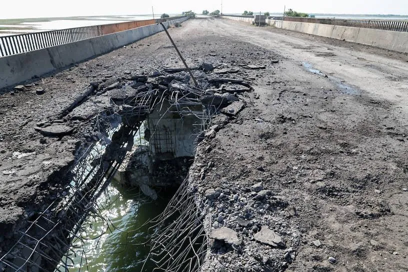
The Crimean Bridge has repeatedly been a specific target. Following attacks in 2022 and 2023, its road section sustained serious damage, although rail service was restored relatively quickly in some instances. This clearly demonstrates that even significant damage to a major crossing does not necessarily mean a complete halt to traffic across it.
Russia, for its part, has also attacked Ukrainian bridge infrastructure. One of the most well-known examples is the bridge in Zatoka, Odesa Oblast, which has been subjected to repeated missile strikes throughout the war.
In all these cases, it was not only the scale of the immediate destruction that mattered. Even the temporary closure of a crossing forces traffic to be rerouted, increases transport distances, and places an additional burden on alternative routes.
Large bridges are built with a safety margin
Engineer and infrastructure specialist Anna Minukova explains that such structures are fundamentally different from small crossings in frontline areas and are designed from the outset with a significant safety margin.
According to Minyukova, a single direct hit is usually not enough to completely take a large bridge out of service. An airstrike can damage the roadway slab, temporarily halt traffic, and require complex repairs, but this does not necessarily mean the destruction of the entire structure.
Minyukova also noted that Kyiv’s transportation system does not depend on a single crossing. If one of the bridges is temporarily taken out of the transportation network, part of the traffic flow is redirected to other crossings over the Dnipro.
In a critical situation, she said, temporary solutions—such as pontoon crossings or water transport—could be used. However, their capacity is significantly lower, so they cannot fully replace a large urban bridge.
Thus, the main consequence of damage to a single bridge would not be the immediate “division” of Kyiv, but rather a sharp increase in traffic congestion, additional strain on other bridges, and problems with transportation logistics.
The history of the South Bridge has now added another chapter

When construction of the South Bridge began in 1983, it was designed for a very different Kyiv.
The city was just preparing for large-scale development of the Poznyaki and Osokorky neighborhoods. It was difficult to imagine the future traffic flow, and the prospect that, four decades later, the bridge would be the target of targeted drone attacks could not have been part of the engineering calculations at all.
During this time, the South Bridge has weathered the collapse of the USSR, the opening of the metro in an independent Ukraine, the rapid growth of the left-bank districts, the rise of car ownership in Kyiv, dozens of repairs, and the outbreak of full-scale war.
On October 1, 2026, another event was added to this history—a Russian drone attack. At the same time, expert assessments highlight an important distinction between the concepts of “hitting the bridge” and “destroying the bridge.” The major Dnipro crossings were designed as massive engineering structures with a safety margin, and Kyiv’s transportation system has several alternative routes.
Therefore, even serious damage to a single crossing could create significant problems for the capital—bringing transportation to a standstill, overloading neighboring bridges, and requiring complex repairs. But this alone does not automatically mean that Kyiv will be divided into two isolated banks.