
Rain and thunderstorms will hit southern Ukraine on August 28

On Friday, August 28, a weather front moving in from the Black Sea will bring unsettled weather to southern and southeastern Ukraine. In other regions of the country, the day will be dry.
On August 28, the weather picture in Ukraine will once again be mixed. In the south and southeast of the country—and at night in most central regions—short-lived rains and, in some places, thunderstorms are expected. In the rest of the country, a high-pressure system from the north will bring dry weather. At night and in the morning, fog is expected in some areas of the Carpathians and the Carpathian Foothills.
Cool air continues to flow in from the northeast, keeping temperatures within the typical autumn range. Winds will be predominantly from the northeast at 5–10 m/s, with gusts of 15–20 m/s in some areas of the south and southeast during the day. Nighttime temperatures will range from 9–14°, and from 13–18° in the south and southeast; daytime temperatures will range from 21–26°, reaching up to 31° in Transcarpathia.
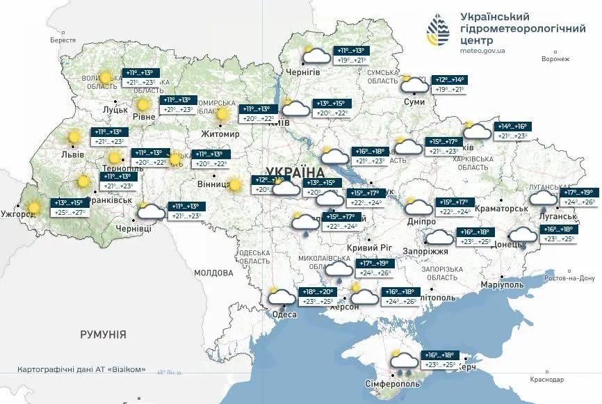
On Friday, August 28, cloud cover in Kyiv will be variable, with no precipitation expected—the capital will end the workweek with dry and comfortable weather. The wind will be from the northeast, 5–10 m/s. Temperatures in the Kyiv region will range from 9–14° at night to 21–26° during the day; in Kyiv, they will range from 12–14° at night to a comfortable 23–25° during the day.
This is reported by the “Ukrhydrometcenter.”
As a reminder, the average temperature in Tokyo has risen by approximately 3°C over the past century. About 1°C of this increase is attributed to climate change, and another 2°C to the urban heat island effect, according to The Japan Times, citing Kazutaku Oku, head of the Climate Change Impact Monitoring Section at the National Institute for Environmental Studies (NIES).
July 2026 was one of the hottest on record for the Arctic landmass: more than 70% of the Arctic’s land and sea areas were warmer than the 1991–2020 average.
Global ocean surface temperatures in July 2026 reached their highest level on record. This could exacerbate global warming and negatively impact marine ecosystems.


