
Ukraine's rivers are rapidly drying up: where water levels have reached critical marks
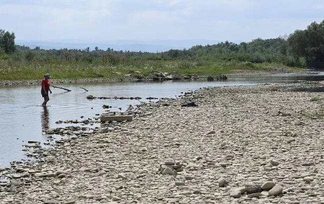
An analysis of water levels in Ukraine’s major rivers for August showed that low water conditions continued to worsen. During the last month of summer, water levels in certain sections dropped to levels typical of drought periods and long-term lows.
The situation proved particularly critical in some waterways—in one river, the flow had virtually stopped.
Why Is River Water Level Assessed?
Ukrainians were reminded that water levels in major rivers are assessed to evaluate the onset (or likelihood of onset) of low water conditions—a hydrological drought.
After all, the hydrological regime of waterways affects:
the operation of water-dependent sectors of the economy;
the water supply to the population of Ukraine.
Recently, the Ukrainian Hydrometeorological Center (UkrGMC) conducted an operational assessment of water levels in major rivers for August 2026 at the locations of active hydrological stations.
It is noted that the average water discharge for August was assessed in accordance with the Regulations on the Procedure for Assessing and Reporting Low Water Levels (Hydrological Drought) in Landwater Bodies of Ukraine.
These regulations define the primary and secondary criteria for assessing the onset (or threat of onset) of low water levels.
Which rivers had the highest water levels in August
According to experts, water levels above normal (149% and 379%) were recorded in August, respectively,
on the Ingulets River (Kryvyi Rih station);
on the Siverskyi Donets River (Zmiiv station).
On which rivers was the situation close to normal?
It is reported that water levels close to normal and slightly above normal (83–107%) were observed:
on the Horyn River (Yampil station);
on the rivers of the Lower Dnieper subbasin—the Vorskla River (Chernechchyna station) and the Samara River (Kocherizhky station);
on the Siverskyi Donets River (Chuhuiv and Izium stations);
on the Ingul River, a tributary of the Southern Bug (Kropyvnytskyi station).
Where water levels were below normal
According to information from the Ukrainian Hydrometeorological Center, water levels below normal (54–79%) were observed during the last month of summer:
on the Dnipro River (Nedanchychi station);
on the Desna and its tributary, the Seim River (within Ukraine);
in the total inflow to the Kyiv Reservoir;
in the lateral inflow to the Dnipro Reservoir;
on the Psel River, a river in the Middle Dnipro sub-basin (Sumy station).
Which rivers have water levels significantly below normal
Water levels significantly below normal (31–49%) were observed throughout August 2026:
in the estuary section of the Pripyat River;
in the tributaries flowing into the Kremenchuk and Kamianka Reservoirs;
on the Western Bug (Kamianka-Buzka station);
on the rivers of the Middle Dnieper subbasin—the Teteriv (Zhytomyr station), Irsh (Ukrainka station), Psol (Hadyach and Zapsillia stations), and Oril (Tsarichanka station) rivers; in the lower reaches of the Sula River (Lubny monitoring station);
on the Uda River, a tributary of the Siverskyi Donets;
on the Tisa River (Rakhiv station);
on the Southern Bug River (Selyshche station);
on the Ukrainian section of the Danube (Reni and Izmail stations).
Where conditions were close to low water
Water levels close to the low-water criteria (21–29%) were observed in late summer:
on the tributaries of the Pripyat—the Styr River (Lutsk and Mlynok gauging stations) and the Horyn River (Derazhne gauging station);
on the rivers of the Middle and Lower Dnieper subbasin—the Teteriv (Ivanivka station), Ros (Fesyuri station), and Vorskla (Kobelyaky station);
on the Southern Bug (Pirogivtsi and Pidhiria monitoring stations);
on its tributary—the Sinyukha River;
on the Prut River (Chernivtsi monitoring station);
on the Tisa (Vylok station).
Where low water levels were observed and intensified
According to data from the Ukrainian Hydrometeorological Center, low water levels were observed and intensified throughout August (based on the primary assessment criterion):
on the Pripyat River—at the hydrological stations at Richytsia (14%) and Lyubiaz (5%);
on its tributaries—the Horyn River (Ozhenyn station—10%), Sluch (Zvyagel and Sarny stations—14–16%), and Uborch (Rudnya-Ivanivska and Perha stations—11%);
on the rivers of the Middle Dnieper subbasin—the Ros (Korsun-Shevchenkivskyi station—19%), Trubizh (Pereyaslav station—16%), Sula (Romny monitoring station—13%), and Uday (Pryluky monitoring station—9%);
on the Dniester River—at the Sambir (11%), Halych (14%), and Zalishchyky (17%) monitoring stations;
in the total inflow to the Dniester Reservoir (17%);
on the Stryi River, a tributary of the Dniester (Verkhne Synyovydne station—18%);
on the Siret River (Storozhynets station—15%);
on the Latorica River (Mukachevo – 18%);
on the Uzh River (Uzhhorod station—16%);
on the Western Bug (Lytovezh station—9%);
on the Southern Bug—at the Trostyanchik and Oleksandrivka stations (7% and 20%, respectively).
Where water levels increased “artificially”
The Ukrainian Hydrometeorological Center reported that water levels higher than those of the driest month were observed only:
on the Siverskyi Donets River (Zmiyiv station);
on the Ingulets River (at the Kryvyi Rih station).
“This is due to the operation of the Dnipro-Ingulets Canal and the Karachunivskyi Reservoir,” Ukrainian authorities explained.
Which rivers are at the lower limit
Water levels within the normal range for the driest month (80–107%) were observed on six rivers throughout August:
the Horyn (Yampil station);
the Seim (Mutyne station);
Psyl (Sumy station);
Samara (Kocherizhky station);
Siverskyi Donets (Chuhuiv and Izium gauging stations);
along the tributaries flowing into the Dnipro Reservoir.
Where the situation is critical for people and ecosystems
On the remaining rivers (whose hydrological regime affects the operation of water-dependent sectors of the economy and the water supply to the population), according to the Ukrainian Hydrometeorological Center, “monthly flow was below the long-term average for the driest month of the year (auxiliary criterion).”
A difficult hydrological situation, associated with river flows remaining below ecological flow rates, was observed (as a percentage of the ecological flow rate):
in the upper reaches of the Pripyat (Rychytsia station—43%);
on its tributary, the Horyn River (Ozhenin and Derazhne stations—42% and 74%, respectively);
on the Western Bug (Lytovezh station—60%);
on the Southern Bug (Trostyanchik station—37%);
on the Dniester (Galich and Zalishchyky monitoring stations—77% and 68%).
“This is critical for the functioning of river ecosystems,” the experts noted.
On which river has the water completely “stopped”
Finally, experts from the Ukrainian Hydrometeorological Center reported that on the Stokhid River—a tributary of the Pripyat (near the Lyubeshiv monitoring station)—there has been a complete absence of river flow since August 5.
In other words, the current there has effectively “stopped,” and the water is simply “standing still.”
This was reported with reference to a post by the press service of the Ukrainian Hydrometeorological Center on Facebook.
In the Kyiv region, restrictions on water use have been imposed due to pollution of the Irpin River.
In the Kyiv region, the Bucha River, a left tributary of the Irpin, has completely dried up.
As a reminder, Lake Svitiaz in Volyn has noticeably shrunk: in some areas, the water has receded dozens of meters from the shoreline, and parts of the territory that were previously flooded are now accessible on foot.
In Kyiv, following the Russian attack on the night of August 8, minor oil contamination was again detected in Lake Kyrylivske and the Syrets Stream.


